
Biolinks Map for South Gippsland
Latest News
Draft Biolinks Map is Open for Feedback
View the draft Biolinks Map and input feedback HERE.
Progress Update Meeting Recording
How to Give Feedback Using the Draft Webmap
For those looking for extra support with the feedback process, further instruction is provided here.
For further information on the Biolinks Mapping Project, contact Cassie, cassie@sgln.net.au, 0448 739 559.
Biolinks Map – Project Summary
The Biolinks Map is a key action within the Biodiversity Protection Plan. James Garden of Ecology Systems supported by Yasmin Kelsall of Confluence Ecology and Community have been engaged for this process.
The mapping process will take a species-led, tenure blind approach and consider all environments across the region, not just those where larger patches of bushland exist. Similar biolink plans have been developed for a number of municipalities across the state, including nearby in the Cardinia Shire region, utilising the General Approach to Planning Connectivity from Local Scales to Regional (GAPCLoSR) method.
This GAPCLoSR method will also be used for the South Gippsland Biolinks Map. It will combine a connectivity modelling approach with feedback from key regional stakeholders including local Landcare representatives. It will also take into account all existing data on vegetation, land mapping and fauna records. Representative groups of fauna with similar ecological and dispersal requirements will be identified. These will be used to model and understand connectivity in the landscape. And this will be used to identify where on-ground action will have the most impact.
We can then, as a community, focus our resources on the most effective actions to address those gaps so native species can maintain or increase their numbers. We also believe the Biolinks Map will provide a well-informed basis for regional planning processes and inspire more investment in the natural values of our landscape.
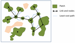
Image provided by James Garden Ecology Systems
Community Information Session
To introduce the project to our members and the broader community, we held an online information session about the project on Wednesday 7 May 2025. See the recording below where James introduces the Biolinks Mapping concept, how it will be created and what it will look like. NOTE: To skip the introduction, go to the second chapter which starts at 5min. James’s 30min presentation is followed by questions.
Public Consultation
2025
As part of this project, we invited stakeholders and local community members with on-ground knowledge of the landscape to share details about the habitat they know well. Their insights have helped strengthen our understanding and refine the modelling process.
We received valuable feedback from across the South Gippsland community, and we sincerely appreciate all the information contributed during this period, particularly observations about vegetation, habitat, and wildlife at specific locations.
The community feedback period has now closed, and the project team is using the collected information to inform the next stage of mapping.
For more information about our Biolinks Mapping project, contact Cassie: cassie@sgln.net.au, 0448 739 559.